Warfare
Aerial Photo
Written by: Mohsen Shirmuhammad,
Translated by: Hadi Qorbanyar
89 دورہ
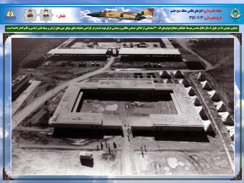
Aerial photos played a key role during the Iran–Iraq War as they helped commanders plan operations and identify enemy deployments.
Any image taken from the sky is considered an aerial photo. These images can be oblique, tilted, or vertical.[1] Militarily, aerial photography is divided into two categories: strategic and tactical. Strategic aerial photography is about producing detailed maps of an enemy’s military and industrial facilities, supply hubs, transport lines, bases, radar sites, force concentrations, and other natural or man-made features of military value. Tactical aerial photography, by contrast, is carried out along frontlines when headquarters needs a close, up-to-date view of enemy positions and fortifications, troop movements, weapons and equipment, communication routes, and so on to plan an operation.[2]
The history of aerial photography goes back to 1858, when the first aerial photo was taken by the Frenchman Félix Nadar from a tethered balloon.[3] The practice later moved to airplanes as aviation developed.[4]
In 1958, with the arrival of RT-33 aircraft in Iran, the 11th Reconnaissance Squadron was formed in the Iranian Army Air Force. Then, the unit formally began taking aerial images. The squadron’s photographic capability expanded after RF-5 and RF-4 aircraft entered service in 1968 and 1971, respectively.[5] As far as the organizational structure is concerned, the 11th Reconnaissance Squadron consisted of a flying element (RF-4 and RF-5 pilots), a photo-analysis section, and a laboratory. The camera maintenance unit was subordinate to the logistics one but worked closely with the Reconnaissance Squadron.[6] This unit also carried out aerial photography during the Dhofar conflict (1973–1976), in which Iranian forces were engaged. The images revealed opposition force locations and supply routes.[7] Before the 1979 Revolution, detailed aerial photos had already been taken of all major targets inside Iraq.[8]
During the eight years of the Iran–Iraq War, the 11th Tactical Reconnaissance Squadron was involved in aerial photography of the combat zones and targets across Iraqi territory.[9] After Iraq’s aerial attack on 22 September 1980, Iran launched a broad series of air operations known as Kaman 99 the very next day.[10] Aerial photos were urgently required to enable intelligence and operations officers to assess enemy losses and damage. The first reconnaissance sortie that day was flown by an RF-4 over Habaniya, Iraq. Once the targeted areas were photographed, the images were quickly delivered to the Iranian authorities to facilitate planning for subsequent operations.[11]
Accurate intelligence on enemy positions was essential in ground operations and aerial bombardments. Aerial photography was one of the main intelligence sources that would reveal the shape, location, positions, and disposition of enemy forces.[12]
For example, aerial photos were required for effective planning of Operation Thamen al-Aemmah (as), as they would not only reveal enemy positions but also show the latest Iraqi troop movements. The 77th Khorasan Division Headquarters of the Army (the operational command) requested daily reconnaissance flights. Sometimes sorties were flown every day, and because the information had to reach the 77th Division Headquarters without delay, specialists would remove the camera magazines from the RF-4 immediately upon landing at Mehrabad and rush them to the lab for film development. Once the images were processed, an initial interpretation was carried out by imagery analysts. That night, the photos — along with their attachments — were flown aboard a Falcon jet to Omidiyeh Air Base, then transported overland to the 77th Division Headquarters near Mahshahr, where the division’s intelligence officers would work on them. Geographic coordinates of enemy positions, command posts, reserve units, and even artillery locations were marked on the images.[13] Those coordinates were then passed to artillery units, enabling them to target the designated points during operations.[14]
Aerial photography was also used in naval operations. For instance, on November 20, 1980, at the Iranian Army Navy’s request, an RF-4 took some images from the Al-Bakr and Al-Amiyah docks, the ports of Umm al-Qasr and Al-Faw, as well as the Kuwaiti coastline. The images were used in Operation Morvarid (November 28, 1980), which significantly undermined Iraq’s naval force capability.[15]
Aerial photos also played a decisive role in planning land offensives. On March 28, 1982, while reviewing photos taken by RF-4 over Khuzestan, analysts found that the aircraft had missed Hur al-Azim. Nonetheless, when returning to the base, the aircraft’s cameras had captured clear and crucial images of the west bank of the Karun River from north of Darkhovein to north of Khorramshahr. When one of the images was analyzed at the Karbala Headquarters, a gap was identified in Iraq’s defensive lines along the Karun’s west bank. That single image revealed a vulnerability, led to adjustments in the planning of Operation Beit al-Muqaddas, and opened a hopeful route for its success.[16]
Also, photos taken by RF-4 during Operation Beit al-Muqaddas in the second half of May 1982 showed a floating bridge linking the Khorramshahr shore to Iraqi-held territory. This multi-section bridge — constructed by joining several islands in the Arvand Rud to support Iraqi forces — was carefully spotted by photo analysts. Once its location was confirmed, orders were issued for its destruction,[17] and on May 24, 1982, two F-4 Phantom jets carried out the strike, successfully destroying the bridge. This left a significant demoralizing effect on the besieged Iraqi troops in Khorramshahr and contributed to their eventual surrender.[18]
In some cases, aerial photography literally saved thousands of lives. Analysis of aerial photos taken on July 29, 1982, during Operation Ramazan revealed a gap between Iranian units on the frontline due to an incomplete link-up. If the enemy had launched a counterattack, it could have led to a human catastrophe. The issue was immediately reported, and the troops withdrew from the area.[19]
From 1984 onward, Iran also began using drones for aerial photography. The first unmanned aerial vehicle, named Talash, was developed by the Islamic Revolutionary Guard Corps (IRGC) and used standard photographic cameras with 135 mm film.[20] Its maximum range was about 5 kilometers, and it mostly flew over frontline positions.[21] During operations Karbala 4 and Karbala 5, taking analog photos of enemy formations by drones provided valuable information to IRGC commanders, allowing them to change tactics and troop deployment in areas where the original plans had been compromised.[22] The next drone model used by the IRGC was Mohajer, which entered service in 1987.[23] Throughout the war, a total of 619 drone missions were flown, covering an area of about 18,570 square kilometers and capturing 53,772 aerial photos.[24]
Reconnaissance flights never stopped throughout the eight years of the war, despite the shortage of pilots, limited flight equipment, including aircraft and cameras, and the pressure of arms embargoes. RF-4 and RF-5 pilots repeatedly risked their lives to complete their missions, bringing both the aircraft and the precious photo footage safely back to bases. Such missions continued until the end of the war.[25] The last aerial photography took place on August 9, 1988.[26]
Sixteen pilots from the 11th Reconnaissance Squadron were martyred while conducting aerial photography over enemy territory. Among them, Major Fereydoun Zolfaqari stood out as one of the most distinguished.[27] Iraq entered the war with minimal aerial reconnaissance capacity, depending on a few MiG-21 aircraft. Over time, the country acquired Soviet MiG-25s and French Mirage fighters, both equipped with advanced reconnaissance systems. Flying at high speeds and altitudes beyond the reach of Iran’s air defenses and fighters, the MiG-25 could freely conduct reconnaissance missions over Iranian airspace.[28]
[1] Rostami, Mahmoud, Farhang-e Vajeh-haye Nezami (Dictionary of Military Terms), Tehran, Setad-e Moshtarak-e Artesh-e Jomhuri-ye Eslami Iran, Pp. 578.
[2] Shirmuhammad, Mohsen, Cheshman-e Oqaab: Hamaseh-ye Gordan 11 Shenasayi Taktiki-ye Niru-ye Havaei va Amaliyat-e Aksbardari-ye Havaei dar Defa Muqaddas (Eagle Eyes: Tactical Reconnaissance Squadron 11 and Aerial Photography in Sacred Defense), Tehran, Markaz-e Entesharat-e Rahbordi-ye NAHAJA, 1396, Pp. 68.
[3] Shirmuhammad, Mohsen va Sama Cheraghpour, Kabootaran-e Musharraf (The Honored Pigeons), Mahnameh-ye Sarbaz, No. 247, Mordad 1396, Pp. 42.
[4] Shirmuhammad, Mohsen, Tarikhche-ye Shenasayi va Aksbardari-ye Havaei (History of Reconnaissance and Aerial Photography), Mahnameh-ye Sanaye Havaei, No. 320, Shahrivar 1398, Pp. 47.
[5] Shirmuhammad, Mohsen, Gordan 11 Shenasayi Rahkoneshi Niru-ye Havaei dar Defa Muqaddas (Tactical Reconnaissance Squadron 11 in Sacred Defense), Mahnameh-ye Saf, No. 433, Tir 1396, Pp. 33.
[6] Ibid., Pp. 33.
[7] Shirmuhammad, Mohsen, Cheshman-e Oqaab: Hamaseh-ye Gordan 11 Shenasayi Taktiki-ye Niru-ye Havaei va Amaliyat-e Aksbardari-ye Havaei dar Defa Muqaddas (Eagle Eyes: Tactical Reconnaissance Squadron 11 and Aerial Photography in Sacred Defense), Pp. 103–105.
[8] Ibid., Pp. 100.
[9] Ibid., Pp. 9.
[10] Ibid., Pp. 136.
[11] Ibid., Pp. 137.
[12] Ibid., Pp. 9.
[13] Ibid., Pp. 193–194.
[14] Abuali, Zahra, Afsar-e Dalsin: Khaterat-e Sarhang Muhammad-Javad Enshaei (Colonel Muhammad-Javad Enshaei Memoirs), Tehran, Nashr-e AJA, 1389, Pp. 144.
[15] Shirmuhammad, Mohsen, Cheshman-e Oqaab: Hamaseh-ye Gordan 11 Shenasayi Taktiki-ye Niru-ye Havaei va Amaliyat-e Aksbardari-ye Havaei dar Defa Muqaddas (Eagle Eyes: Tactical Reconnaissance Squadron 11 and Aerial Photography in Sacred Defense), Pp. 150.
[16] Ibid., Pp. 210–213.
[17] Ibid., Pp. 218.
[18] Shirmuhammad, Mohsen va Fatemeh Momayezi, Aksbardari-ye Havaei va Tarahi-ye Amaliyat-e Beit al-Muqaddas (Aerial Photography and Planning of Operation Beit al-Muqaddas), Faslnameh-e Eqtedar-e Havaei, No. 15, Bahar 1401, Pp. 18.
[19] Shirmuhammad, Mohsen, Aks Havaei va Nejat-e Hezaran Razmandeh (Aerial Photography and Saving Thousands of Soldiers), Faslnameh-e Eqtedar-e Havaei, No. 10, Bahar va Tabestan 1399, Pp. 60–62.
[20] Saleminejad, Abdolreza, Pahpad dar Defa Muqaddas: Ravand-e Sheklgiri va Naqshafarini-ye Yegan-e Pahpad-e Sepah dar Defa Muqaddas (Drones in Sacred Defense: The Formation and Operational Role of the IRGC Drone Unit during the Sacred Defense), Tehran, Nilouferan, 1395, Pp. 49.
[21] Shirmuhammad, Mohsen, Cheshman-e Sepehr: Tarikh-e Shenasayi va Aksbardari-ye Havaei dar Iran (Sepehr’s Eyes: History of Aerial Reconnaissance and Photography in Iran), Tehran, Markaz-e Entesharat-e Rahbordi-ye NAHAJA, 1401, Pp. 433.
[22] Ibid.
[23] Saleminejad, Abdolreza, Ibid., Pp. 163.
[24] Shirmuhammad, Mohsen, Cheshman-e Sepehr: Tarikh-e Shenasayi va Aksbardari-ye Havaei dar Iran (Sepehr’s Eyes: History of Aerial Reconnaissance and Photography in Iran), Pp. 434.
[25] Shirmuhammad, Mohsen, Cheshman-e Oqaab: Hamaseh-ye Gordan 11 Shenasayi Taktiki-ye Niru-ye Havaei va Amaliyat-e Aksbardari-ye Havaei dar Defa Muqaddas (Eagle Eyes: Tactical Reconnaissance Squadron 11 and Aerial Photography in Sacred Defense), Pp. 9.
[26] Ibid., Pp. 268.
[27] Shirmuhammad, Mohsen, Gordan 11 Shenasayi Rahkoneshi Niru-ye Havaei dar Defa Muqaddas (Tactical Reconnaissance Squadron 11 in Sacred Defense), Pp. 32.
[28] Shirmuhammad, Mohsen, Cheshman-e Oqaab: Hamaseh-ye Gordan 11 Shenasayi Taktiki-ye Niru-ye Havaei va Amaliyat-e Aksbardari-ye Havaei dar Defa Muqaddas (Eagle Eyes: Tactical Reconnaissance Squadron 11 and Aerial Photography in Sacred Defense), Pp. 201–203.