Sites
Arvandkenar
Afsaneh Sadeghi
331 Views
Abadan is the southernmost city of the Khuzestan Province. It shares a border with the cities of Shadegan and Khorramshahr to the north, the Persian Gulf to the east, south, and southeast, and Iraq to the west and southwest. This county has two districts called Markazi and Arvandkenar. The city of Arvandkenar is the center of the Arvandkenar district, and the town of Abadan is the center of the Central District of Abadan County.
Arvankenar is one of the areas of Arvankenar District, Abadan. It is located 50 kilometers southeast of Abadan city, at the end of Jazizeh in Abadan. This city came into being in the early 1970s, via a combination of twelve villages from the village of Mo'mareh in the Arvankenar district. Nevertheless, despite the collection of these villages developing into an urban area, a single, continuous structure was not formed, and the only element connecting the villages was a national road.[2]
This area, which was formerly called Qasbeh or Gasbeh (also called Qasbeh al-Ansar), was renamed Arvankenar during the second Pahlavi period in 1959. The city has a port and loading facilities for small launches, while the closet land border is in the south of Abadan Island, before the city of Faw, the famous export port and oil terminal of Iraq. The people of this region are Arabic-speaking and most of them are Shia Muslims, but a small number of Sabeans are also present. Naturally, Arvankenar is a flatland consisting of Mesopotamian sediments, as well as sediments of the Zagros Mountains.[3]
Before the start of the war, the Arvankenar district was subjected to sabotage by counter-revolutionary groups and Arabs loyal to the Ba'athist regime in Iraq. Examples of which include the December 17, 1980 explosion in the village of Sahneh and the explosion on February 10, 1981 in the Sirus School. During this time, the enemy carried out extensive provocations on the west bank of the Arvand River and on the outskirts of Arvankenar.[4]
On July 23, 1980, the Iraqi navy concentrated its fleet to the area of the Arvand River that it had under its control. The most important checkpoints of Iran in the Arvankenar district were located at Minouhi, Saaduni, Nahr Alishir, Nahr Abtar and Khormal, which operated before the checkpoints of northern and southern Faw, Iraq. Before the start of the war, some of these checkpoints, such as the Khorramal Arvankenar checkpoint (especially on September 10 and 30, 1980), were attacked by the Iraqi navy.[5]
As the occupation of the area led to the capture of the mouth of the Arvand River, the Iraqi army made extensive efforts to enter and occupy the island of Abadan, which failed due to the steadfastness of its defenders. Opposite the city of Arvankenar and on the other side of the Arvand River is the Iraqi city of Faw, which was captured by Iranian forces after the Battle of Dawn 8.[6]
The proximity of Arvankenar to the city of Faw, which is the most important axis of communication between Iraq and the Persian Gulf, added to the geographical importance of this region, especially during the time of the Sacred Defense. In this way, with the beginning of the war, the city of Arvankenar was practically besieged by the enemy. With the confrontation of the Iranian fighters and the breaking of the siege of Abadan, the threat of the Iraqis to capture Arvankenar was eliminated, however, the Arvankenar district and its settlements, as well as all the coasts of this region, remained under fire.[7]
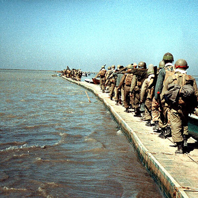
Arvankenar then became a training ground for fighters preparing for Operation Dawn 8, which occurred in February 1986. In order to stabilize the force and meet the engineering needs of the region, the engineering units prepared the ground for the operation before the operation, with various activities, such as constructing antenna-shaped roads, constructing artillery positions and creating surface-to-air missile positions in Arvankenar. In Operation Dawn 8, the critical location of Arvankenar, along with its vast groves, which were a good cover for the supply and movement of forces, was very effective in the success of the operation. In September 1986, after the successful operation of Karbala 3, the fighters of Camp Noah, moving from the southern parts of Arvankenar, destroyed the two ports of Al-Umayyah and Al-Bakr, which were the two most important oil terminals and naval bases in the Persian Gulf, resulting in the dismantling of the enemy formation in the Persian Gulf. With the end of the war and the implementation of Resolution 598, the Arvand River was once again defined as the western border of Iran and the Arvankenar coast was used by the people of this region.[8]
After the end of the war, eight memorials were erected in the area to commemorate the martyrs of the Operation Dawn 8.[9]
[1]Pourjabari, P., Atlas of Epic Geography Khuzestan in War, Tehran: Sarir, 2010, p.71.
[2] Foroudi, Gh., Atlas of West and Southwest Operational Zones, Tehran: Foundation for the Preservation of Relics and Publication of Sacred Defense Values, 2017, p. 122.
Pourjabari, P., Epic Geographical Atlas, p.81.
[4]Ibid
[5] Ibid, Pp. 81 and 82.
[6] Foroudi, Gh, Atlas of Operational Zones West and Southwest, p.122.
[7] Pourjabari, P., Epic Geographical Atlas, p. 82.
[8] Ibid
[9] Foroudi, Gh, Atlas of Operational Zones West and Southwest, p.122.


